13 June 2024 by Georgie Tugwell
This blog is part three of a blog series and we recommend reading ‘A novel Biodiversity Baselining Approach’ first to fully understand the biodiversity baselining package and its objectives. Here, we explore the package’s plant metric and discuss what goes into plant abundance and species richness monitoring, reporting and verification (MRV).
Who Are We?
An introduction to the biodiversity baselining developers:
The strategic partnership between rePLANET and Mozaic Earth combines technological and ecological expertise to revolutionise biodiversity quantification.
Plants are a Priority
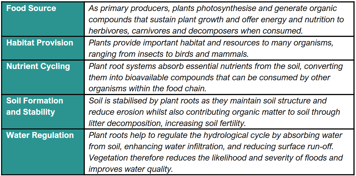
Plants are key indicators of ecosystem health and integrity. Changes in plant species composition and abundance can reflect broader shifts in environmental conditions, such as climate change, habitat degradation, or pollution. Monitoring plant diversity as a metric therefore provides valuable insights into overall ecosystem health – If the plants are doing well, it is likely that everything else is! This is because plants play fundamental roles in ecosystems:
When it comes to biodiversity uplift projects, baselining plant species richness and abundance is key for tracking progress. In many instances, farms and estates have incredibly low plant species richness and abundance due to years of intensive agriculture or land management without consideration for nature. Loss of plant populations negatively impacts the abundance and diversity of other important taxa such as pollinators. Regenerative practices and conservation strategies that support plant community recovery are therefore essential for enhancing site ecosystem services such as pollination and, in turn, agricultural productivity. By quantifying increases in this metric, the effectiveness of such strategies can be monitored, and the biodiversity uplift created can be translated into credits and ESG reports. So, how do we do this?
Harnessing Technology to Facilitate Plant MRV
Together, rePLANET and Mozaic Earth have developed an intuitive smartphone app which forms a key component of our baselining package; this app is used to collect baseline data for the plant biodiversity metric. Farm and estate teams as well as corporate employees can download the app and use it to collect accurate, geo-located data on their sites which is shared with expert ecologists for scientific analysis.
The plant metric sampling sites are determined by statistical stratification, adopting this approach enables us to collect representative, unbiased site data reflecting the baseline scenario of a site without surveyors having to monitor absolutely everything! The Mozaic Earth platform automatically converts this complex plant sampling approach into a simple list of ‘Missions’ to be undertaken by data collectors on the ground, without the need for additional training. Once surveyors download the Mozaic Earth App these missions can be launched and simple, clear instructions guide users through the data collection process, see figure 1.
To begin data collection for plant missions, surveyors will first need to head to sampling locations using the app map function. Once within the 1-hectare plot, you will see 15 check–points, at each point a series of photographs of the quadrat on the ground should be taken. When all the check–points have been completed, that is it, one plant mission is done! The number of missions assigned to a site is typically dependent on its size. The app is easy to operate and has useful functions such as always directing you to the nearest sampling points to increase survey efficiency. All survey missions can be completed offline, and data will be synched when your phone reconnects to the internet.
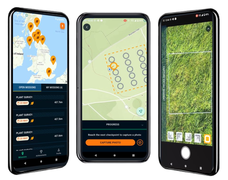
Figure 1: The Mozaic Earth Smartphone App. Dashboards encountered when using the app to monitor baseline species richness and abundance of plants.
You may be wondering what happens with the photos that you capture. Expert botanists will receive and analyse all of the media that you have collected remotely using the Mozaic Earth platform. This establishes species’ richness and abundance values within each quadrat. A baseline plant biodiversity value is then calculated for the entire project site using species lists and relative abundance values; this acts as a reference point, enabling the demonstration of biodiversity uplift in the future. Embedding this biodiversity monitoring approach into the work of field staff and employees enables consistent data collection year after year, meaning you will now be able to see trends in biodiversity changes and better understand the impact of your actions!
NOTE: The rePLANET and Mozaic Earth biodiversity baseline pilot packages are running across a select few UK sites in 2024, the official package launches in 2025.
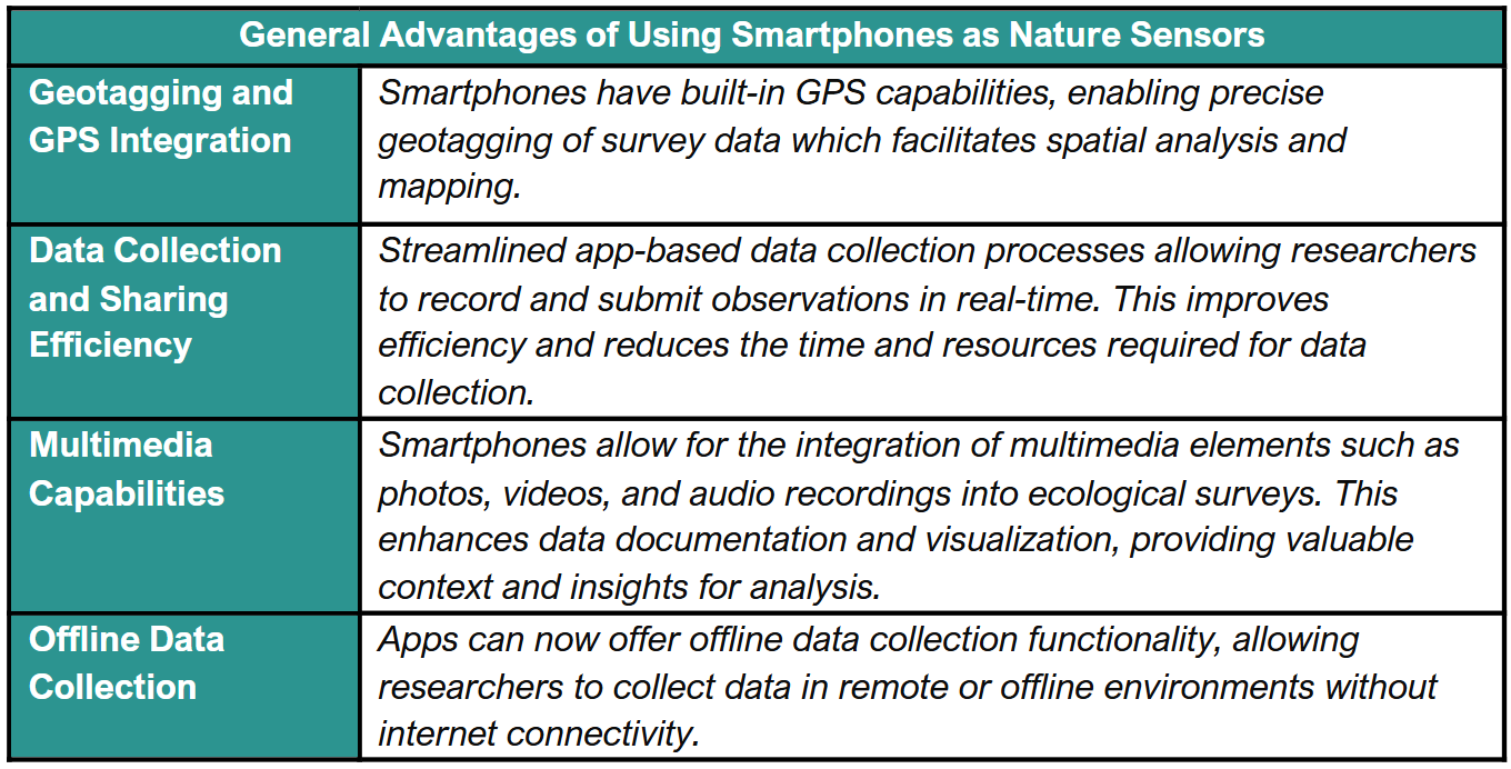
Advantages of App-based Ecological Data Collection
Traditional paper-based ecological surveys are time-consuming and expensive to conduct. Scaling these surveys can be challenging, especially as we already face a global shortage of skilled ecologists. However, by utilizing smartphones, and engaging those working on project sites, the package effectively addresses these challenges. Furthermore, there are numerous benefits to utilizing the Mozaic Earth smartphone app for ecological data collection:

Summary
We selected the plant metric for the biodiversity baselining package as quantifying plant species richness and abundance is imperative for biodiversity projects, providing insight into ecosystem dynamics, environmental changes, and the effectiveness of conservation strategies implemented to safeguard biodiversity. Leveraging the Mozaic Earth platform for plant surveys enhances data collection efficiency, accuracy, and accessibility, ultimately contributing to improved outcomes and informed conservation and management decisions.